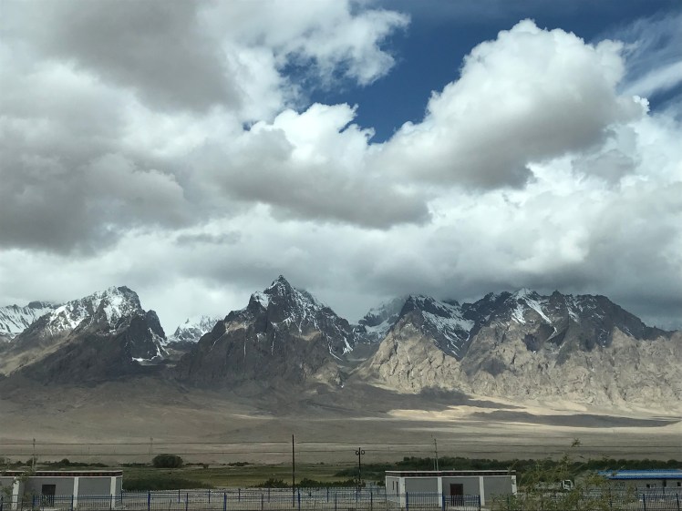
From Kashgar, we started the infamous Karakoram Highway, one of the highest paved roads in the world (maximum elevation is 15,466 ft). The highway traces one of the many paths of the ancient Silk Road. A path crossed and written about by Marco Polo. The highway was built by the governments of Pakistan and China. Construction started in 1959, then was completed and opened to the public in 1979. During time of construction, approximately 1000 workers lost their lives, mostly due to landslides or falls (about 810 Pakistanis and about 200 Chinese). The highway cuts through the collision zone between the Eurasian and Indian plates, where China, Tajikistan, Afghanistan, and Pakistan come within 160 miles of each other. This inevitably gives epic views of stunning mountain ranges in all directions!
After leaving Kashgar, the massive Pamir Mountains start coming into sight. Also referred to as “the roof of the world”, due to what’s called the Pamir Knot, a unique geographical feature formed by the junction of the Himalayas, Tian Shan, Karakoram, Kunlun, and Hindu Kush ranges. We stopped to enjoy lunch in a traditional ger at Lake Karakul. We weren’t the only group taking in the lake view…a massive motorcycle club traversing much of Asia was also stopped, comparing route notes with each other and snapping photos of their Harley-Davidsons.


We carried on to Tashkurgan, the most western town in China and last town before reaching the Pakistan border, where we stayed for the night in a newly built and very basic hotel. Due to Tashkurgan’s location close to the borders of Tajikistan, Afghanistan, and Pakistan, it was a longstanding history along the Silk Road. While the town is very small these days and mostly used as a simple stopover between Pakistan and Kashgar, it was worthwhile to visit the ruins of Tashkurgan Fort. Strategically built 2000 years ago to keep watch of all surrounding mountains for intruders.


The next morning we continued up the KKH to the border of Pakistan and the Khunjerab Pass. The mountainous scenery started including more and more snow the higher we climbed. The Chinese immigration checkpoint was relatively painless. Typical and precise questions, confirmation identification, visa, and luggage contents. We ended up waiting around for about an hour before given approval to proceed, but the wait worked in our favor as our guide shared the tip of stocking up on alcohol from the duty-free shop. We won’t be finding any alcohol in Pakistan!
Once on the road again, an armed Chinese guard joined our bus up until the next checkpoint and we were asked to pull the curtains. The land was barren and clearly used for military purposes. The route took as near the Wakhan Corridor, a narrow strip of Afghanistan territory, wedged between the Pamir Mountains, formed by an 1893 agreement between the United Kingdom and Afghanistan, as a buffer between the Russian Empire (Russian Turkestan, present-day Tajikistan) and the British Empire (British India).
In just short of an hour, we reached the gates of the Khunjerab Pass. We were warned we would be swarmed by local Pakistanis excited to see foreigners, and that was no exaggeration! Our bus was surrounded by curious and eager local tourists from various parts of Pakistan. As soon as we disembarked the bus to take in the surrounding views, we became selfie targets. It was immediately overwhelming, but in the matter of minutes, I caught my breath, and decided to take my own selfies with them! An immersion experience I’ll never forget. You would have thought we were world-renowned celebrities!


Now heading down from the 15,397 ft. pass, we made our way to Sost for Pakistan’s customs and immigration checkpoint. All passports and visas were double and triple checked by local authorities. In order to keep up with the ever-changing highway conditions, we switched from our large bus into multiple 4×4 all-terrain vehicles. Such a mountainous region endures constant fluctuation – glacier melt causing floods and/or landslides, heavy snow shifting the pavement, falling rocks blocking roadways, etc. As a caravan we headed down toward the small village of Passu, one of the oldest settlements in Upper Hunza, and our destination for the night.
The endless stunning views were already keeping us in awe, but the further we entered into the Gilgit-Baltistan region of northern Pakistan, the more dramatic the mountains became. We gawked at jagged peaks and glaciers lining the highway. It’s said this region is among very few places in the world where glaciers still grow (thanks, global warming).


Sadly, a fellow traveler from our group was stuck in Sost dealing with bureaucratic visa logistics, as his flight to China had a quick layover in Islamabad, and apparently the airport stamped his passport, implying his single-entry visa had already been used. Our group tuckered in for the night at the humble Passu Ambassador Hotel, all with high hopes his visa situation would get resolved. Very unfortunately, they ended up forcing him to travel back to China. He was not allowed to proceed into Pakistan, even after our guide’s pleading. Early the next morning we were able to say our goodbyes before separating and going in opposite directions. One traveler down, due to a mishap no one could have foreseen!
